After public comment at a recent city council meeting regarding the acreage of the Salish Lodge and Spa Expansion project caused some confusion, the project’s actual size has been clarified.
During the Nov. 13 city council meeting, the council heard public comment asking if the actual acreage of the Salish Expansion, the Muckleshoot Indian Tribe’s upcoming development project, was closer to 100 acres than the listed 49.6 acres in the final master plan.
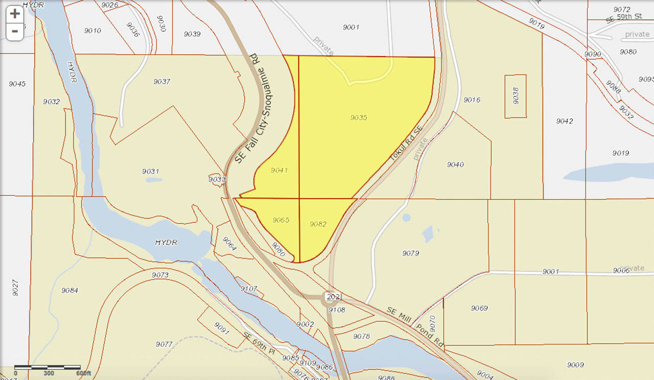
A large map was presented during the pubic comment section of the meeting, showing one of the parcels as much larger than the presented scope of the project. The map showed a parcel almost 60 acres big, instead of the 8 acres that was listed on the project map. The discovery of a larger than expected acreage was said to have come from the legal description of the property from the second amendment to the development agreement. The Valley Record also printed a letter to the editor repeating the claim.
The land cited for the expansion project is broken up into four parcels A, B, C and D in the General Land Use Application. Alternatively, the parcels are labeled as B, F, H and L in the Final Salish Expansion Development Agreement. The claim was made that Parcel D/L was much larger than listed on the project maps, and that it extended west for almost 60 acres.
Community development director Mark Hofman said that was incorrect. Hofman cited the descriptions of each parcel used for the expansion project. The first line of Parcel D’s description reads “That portion of the following described property lying east of the east margin of the right-of-way of State Road No. 2 (also known as SR 202).” Those parcel descriptions are used in both the General Land Use Application and Final Salish Expansion Development Agreement.
The description clearly specifies the land Parcel D refers to is east of the east margin of SR 202, the road that cuts north between the current Salish Lodge and Spa and the planned expansion area.
By using the King County Geographic Information System’s parcel viewer function, the four parcels can be found in a map view and all are registered under the Muckleshoot Indian Tribe. Parcel D — referred to as parcel number 9041 in the General Land Use Application — is only 8.6 acres and runs north from the middle of the expansion until it hits county-owned land. It sits on the east side SR 202 right-of-way, exactly as described in the application and the final development agreement.
The map presented at the city council meeting also included the two parcels to the west of Parcel D as part of the 60 acres, but the King County parcel viewer shows that both of those pieces of land are owned by Puget Sound Energy.
Hofman also clarified that the final development agreement is the sixth amendment of the document, and with its adoption all previous amendments are no longer legally relevant. The only document that has precedent is the final amendment.
The claim was also made that the city did not notify residents in nearby parcels based on the alleged 60-acre size, but Hofman said the city did directly mail residents within a 2,000-foot radius of the project’s actual size, when the minimum requirement is only 500-feet.
Together, the four parcels on the county parcel viewer map are consistent with the proposed development project by the Muckleshoot Tribe.


